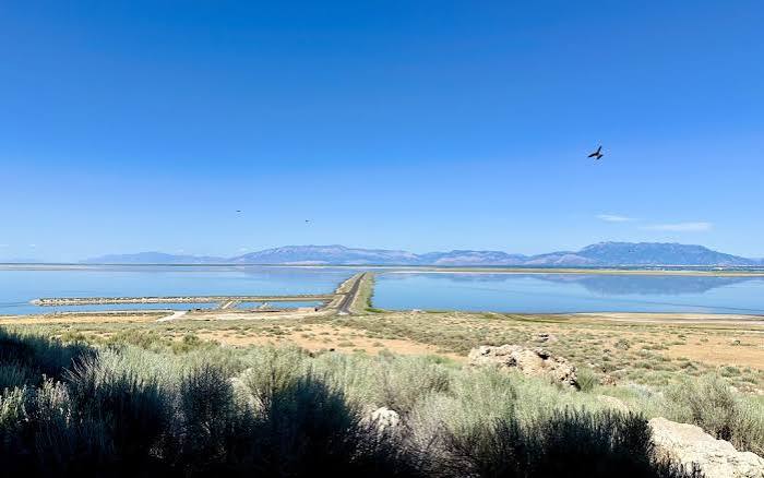
Imagine a lake so vast it could swallow modern-day Lake Michigan, with waves crashing against mountain slopes in what is now the arid desert of Utah. That was Lake Bonneville, a prehistoric colossus that existed during the last ice age, roughly 32,000 to 14,000 years ago. Its footprint spans parts of Utah, Nevada, and Idaho, and its legacy is etched into the landscape in ways you can still see today if you know where to look.
When Lake Bonneville vanished, it didn’t just disappear. It left behind a suite of remnants—from the salty expanse of the Great Salt Lake to the razor-flat Bonneville Salt Flats—and a geological story that scientists still study to understand climate change, catastrophic floods, and even the Earth’s crust. This article explores what the lake left behind, why those leftovers matter, and how they’ve shaped everything from land-speed records to human settlement.
The Lake That Ruled the Great Basin
Lake Bonneville was a pluvial lake, formed during the Pleistocene when the climate was cooler and wetter. At its peak, around 18,000 to 16,500 years ago, it covered roughly 20,000 square miles—about the size of Lake Michigan. Its deepest point plunged to around 1,000 feet, making it a formidable inland sea.
The lake wasn’t just a static body of water. It had a dynamic history, with cycles of rise and fall recorded in its sediments. Geologists identify these as the Bonneville, Provo, and Gilbert cycles, each leaving distinct layers of mud and minerals that read like a diary of ancient climate.
The Great Breach: A Flood That Reshaped the Land
Around 14,500 years ago, Lake Bonneville reached its tipping point. It overtopped its natural rim at Red Rock Pass in southeastern Idaho, and the resulting breach unleashed a catastrophic flood. Known as the Bonneville Flood, it drained a significant portion of the lake in weeks or months, carving the Snake River Plain and leaving scabland features downstream.
This wasn’t just a local event. The flood’s power is a case study in catastrophic geomorphology, and it helped scientists understand how sudden water releases can reshape entire landscapes. After the breach, the lake stabilized at a lower level, known as the Provo shoreline, before slowly receding as the climate warmed.
The Remnants: From Great Salt Lake to Salt Flats
The lake’s disappearance left a chain of remnants, each with its own character:
- Great Salt Lake: The largest survivor, now a shallow, hypersaline body of water—so salty that only brine shrimp and algae can thrive.
- Utah Lake: A freshwater remnant in Utah Valley, vital for local ecosystems and agriculture.
- Sevier Lake: Mostly dry now, a playa that occasionally fills with water.
- Bonneville Salt Flats: A vast, flat crust of salt covering about 30,000 acres in northwestern Utah.
- Great Salt Lake Desert: The broader playa region surrounding the salt flats.
Each remnant tells a piece of the lake’s story. The salt flats, for instance, are the result of the final waters evaporating, leaving behind concentrated salts—sodium chloride, potassium, magnesium, and sulfates.
Ancient Shorelines: Benches in the Mountains
One of the most striking remnants is not water at all—it’s the ancient shorelines. As you look at the Wasatch Range or the Oquirrh Mountains, you can see horizontal benches etched into the slopes. These are wave-cut terraces and gravel bars from when the lake lapped against the mountains.
The highest, called the Bonneville shoreline, marks the lake’s maximum extent. A secondary one, the Provo shoreline, reflects the post-breach stabilization. These shoreline features are among the clearest evidence of past climate change in the Quaternary period.
Beyond shorelines, the lake left spits, bars, and tombolos—like Stockton Bar and the Stansbury Island tombolo. There are also tufa deposits, calcium carbonate formations created by algae and spring activity along the old shorelines. Gilbert Peak, in the Oquirrhs, was once an island in the ancient lake.
The Bonneville Salt Flats: A Playground for Speed
The Bonneville Salt Flats are more than just a geological curiosity—they’re a world-famous racing venue. Since 1914, the flats have hosted land-speed records, thanks to their flat, hard, perfectly level surface. The crust is so smooth that it’s ideal for high-speed runs.
Notable records include Malcolm Campbell’s 301 mph run in 1935, Craig Breedlove’s 400+ mph in 1963, and Andy Green’s supersonic 763 mph in 1997 in the ThrustSSC. The Bonneville Speedway, managed by the Bureau of Land Management, is a designated racing area.
But the flats also have an industrial side. They’ve been commercially mined for salt and minerals since the early 20th century, which has raised questions about how extraction affects the surface’s stability and racing quality.
Human History Along the Ancient Shores
The lake’s remnants have shaped human history, too. Paleo-Indians, including Clovis cultures, hunted megafauna along the receding shores. Later, Fremont and Shoshone peoples used the wetlands and marshes that formed around the remnant lakes.
In the 1840s, the Great Salt Lake Desert became a notorious obstacle for emigrants. The Donner Party crossed it in 1846 with disastrous results, and other wagon trains suffered in the treacherous salt crust. When Mormon pioneers arrived in 1847, they settled in the Salt Lake Valley, using the remnants for water, agriculture, and salt extraction.
In 1869, the Transcontinental Railroad was completed at Promontory Summit, crossing the northern edge of the old lakebed—a route that would have been underwater just millennia before.
Scientific Significance: A Natural Laboratory
Lake Bonneville is a type locality for pluvial lake studies worldwide. Its shorelines and sediments provide a detailed record of climate change, and its history helps calibrate glacial-isostatic adjustment models. The weight of the lake depressed the Earth’s crust, and as the water disappeared, the crust has been rebounding—a slow, ongoing process that scientists can measure.
The Bonneville Flood is a key case study in catastrophic flood geomorphology, helping researchers understand how sudden water releases shape landscapes. And the lake’s sediments are a treasure trove for geologists, with each layer holding clues about ancient climates and ecosystems.
The Legacy Lives On
Lake Bonneville may be gone, but its legacy is all around us. From the shores of the Great Salt Lake to the speed records on the salt flats, from the benches on the mountains to the sediment cores in labs, the lake’s influence persists. It’s a reminder that landscapes are not static—they’re shaped by forces we can still see in action today.
Lake Bonneville’s story is one of dramatic transformation—a lake that once rivaled the Great Lakes, that carved canyons with a catastrophic flood, and that left behind a landscape of salt, water, and stone. Its remnants continue to shape the environment, the economy, and even human adventure. The next time you see the Great Salt Lake or drive across the Bonneville Salt Flats, you’re looking at the ghost of a giant—and a living laboratory for understanding our changing planet.
Summary
- Lake Bonneville was a massive pluvial lake during the last ice age, covering ~20,000 sq miles at its peak.
- A catastrophic breach around 14,500 years ago caused the Bonneville Flood, carving the Snake River Plain.
- Remnants include Great Salt Lake, Utah Lake, Sevier Lake, and the Bonneville Salt Flats.
- Ancient shorelines, spits, and tufa deposits are visible in the surrounding mountains.
- The Bonneville Salt Flats are a premier land-speed racing venue and a site of salt mining.
- Lake Bonneville is crucial for studying climate change, crustal rebound, and catastrophic floods.
FAQ
Q: How big was Lake Bonneville compared to today’s lakes?nA: At its maximum, Lake Bonneville covered about 20,000 square miles, roughly the size of Lake Michigan. It was about 1,000 feet deep at its deepest point.nnQ: What caused the Bonneville Flood?nA: The lake overtopped its natural rim at Red Rock Pass in Idaho, causing a breach that released a catastrophic flood, draining a significant portion of the lake in weeks or months.nnQ: Where can I see evidence of Lake Bonneville today?nA: Look for horizontal benches on mountains like the Wasatch Range—these are ancient shorelines. You can also visit the Great Salt Lake, Utah Lake, or the Bonneville Salt Flats.nnQ: Why is the Bonneville Salt Flats so flat and hard?nA: The salt flats formed as the lake’s final waters evaporated, leaving a thick crust of salts that is naturally level and hard, making it ideal for racing.nnQ: How did Lake Bonneville affect human history?nA: The lake’s remnants provided water, salt, and wetlands that attracted early peoples, and later challenged pioneers like the Donner Party. The railroad also crossed the old lakebed.