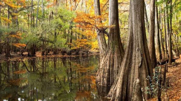
Deep in central South Carolina, a river breathes. About ten times a year, the Congaree River swells over its banks and spreads across a 26,000-acre floodplain, submerging up to 80% of the land under a shallow, nutrient-rich sheet of water. This isn’t a disaster it’s a life-giving pulse that sustains one of the last old-growth bottomland hardwood forests in the Southeast.
Congaree National Park, just 20 miles southeast of Columbia, holds trees that stretch over 150 feet into the sky. Loblolly pines, sweetgums, and cherrybark oaks here are record-breakers the largest known individuals of their species in the United States. The secret to their towering success lies not in the soil, but in the floodwaters that periodically wash over them.
A Forest That Dances with the River
Most forests rely on rain and soil for their nutrients. Congaree has a different partner: the Congaree River. As it meanders across the Atlantic Coastal Plain, the river carries silt and clay eroded from the Piedmont. When it floods, it deposits this alluvium across the floodplain, fertilizing the land like a natural compost spread. This constant renewal is why the trees grow so fast and so tall.
Ecologists call this relationship the “flood pulse concept.” It’s a simple idea: the periodic rise and fall of river water is the main driver of life in a floodplain. The floodwaters don’t just add nutrients; they also carry fish and aquatic invertebrates into the forest, where they feed and spawn in the temporary shallows. When the water recedes, it leaves behind mudflats where fast-growing plants quickly germinate. The timing, duration, and depth of each flood determine which species thrive in which zone of the floodplain.
Three Neighborhoods, One Forest
Walk from the river’s edge inland, and you’ll pass through distinct neighborhoods, each shaped by how often it floods.
Levee forests sit on the natural embankments built up by centuries of sediment deposits. These high spots flood only occasionally, so they support drier-loving species like sweetgum, water oak, and loblolly pine. The loblolly pines here are the giants—some exceed 150 feet, making them national champions.
Bottomland hardwood forests occupy the middle ground. They flood a few times a year, so they host species that can tolerate wet feet: cherrybark oak, swamp chestnut oak, and American beech. These trees are also record-setters, with cherrybark oaks reaching heights that rival the pines.
Swamp forests are the lowest zones, where water stands for much of the year. Here, bald cypress and water tupelo dominate. Their trunks flare at the base, and their roots form “knees” that stick up out of the water—structures that help anchor them in the soft, wet soil and may aid in gas exchange.
The Birth of Oxbow Lakes
The river that feeds this forest is a restless wanderer. It constantly erodes its outer banks and deposits sediment on its inner curves, causing its meanders to migrate over time. Occasionally, a meander loop becomes so tight that the river breaks through its narrow neck during a flood, cutting off the old loop. That abandoned curve becomes an oxbow lake—a crescent-shaped, still-water channel.
Congaree has several oxbow lakes, including Weston Lake and Muck’s Lake. They start as open water, but as they slowly fill with organic matter and sediment, they transition into swampy wetlands, and eventually into forested areas. This ecological succession is visible across the park, with old oxbows now supporting mature forests.
Biodiversity in a Watery World
Despite its frequent flooding—or perhaps because of it—Congaree is a biodiversity hotspot. The park hosts over 75 tree species and more than 900 vascular plant species. It’s also home to a rich array of wildlife: river otters, bobcats, and the endangered red-cockaded woodpecker, which nests in the park’s mature pines. The state-endangered swallow-tailed kite soars overhead, and the floodplain’s temporary pools teem with amphibians and reptiles.
One of the best ways to see this life is from a canoe. Cedar Creek, a blackwater tributary, winds through the park and offers a quiet, close-up view of the swamp forests and their inhabitants.
A History of Survival
Congaree’s old-growth forest is a rare survivor. In the early 20th century, most bottomland hardwood forests in the Southeast were clear-cut for timber. Congaree was spared largely because its frequent flooding made logging difficult and expensive. The trees stood tall, but the threat didn’t pass. In the 1960s and 1970s, a proposed clear-cut sparked a grassroots campaign to save the forest. Their efforts paid off: the area was designated a national monument in 1976, a UNESCO Biosphere Reserve in 1983, and finally a national park in 2003.
Today, visitors can explore this living museum via a 2.4-mile boardwalk that loops through the floodplain. When the river is low, the boardwalk offers dry passage; during floods, it becomes a floating dock above the water. For a more immersive experience, kayakers can paddle the park’s waterways, gliding between cypress knees and beneath canopies of ancient trees.
Congaree National Park is more than just a collection of tall trees. It’s a testament to the power of natural processes—floods, meanders, and succession—working together to create an ecosystem of extraordinary richness. Its survival is a reminder that protecting wild places means protecting the dynamic forces that shape them. The next time the Congaree River rises, it’s not a threat; it’s the forest’s heartbeat.
Summary
- Congaree National Park is one of the last old-growth bottomland hardwood forests in the Southeast, covering 26,000 acres in South Carolina.
- The Congaree River floods about 10 times a year, depositing nutrient-rich silt that sustains record-breaking tree growth.
- The park features distinct forest zones—levee, bottomland, and swamp—each adapted to different flood frequencies.
- Oxbow lakes, formed when river meanders are cut off, are scattered across the landscape and show ecological succession.
- The park is home to over 75 tree species and diverse wildlife, including endangered species like the red-cockaded woodpecker.
- Congaree was saved from logging due to frequent floods and later protected, becoming a national park in 2003.
FAQ
Q: What makes Congaree’s trees so large?
A: The periodic flooding of the Congaree River deposits nutrient-rich silt and clay (alluvium) across the floodplain, fertilizing the soil. This natural fertilization, combined with a long growing season, allows trees to grow exceptionally tall and fast.
Q: How often does Congaree flood?
A: On average, the river floods about 10 times per year, sometimes covering up to 80% of the park. The timing and depth of floods vary seasonally and annually.
Q: What is an oxbow lake?
A: An oxbow lake forms when a river meander loop is cut off during a flood, leaving a crescent-shaped, still-water channel. Over time, it fills with sediment and organic matter, eventually becoming a wetland or forest.
Q: Can visitors see the floodplain without a boat?
A: Yes, a 2.4-mile elevated boardwalk lets visitors walk through the floodplain during dry periods. During floods, the boardwalk may be partially underwater, but a canoe or kayak can still be used.
Q: Why is Congaree important for wildlife?
A: The floodplain provides a rich habitat for many species, including endangered ones like the red-cockaded woodpecker and swallow-tailed kite. Floodwaters also support fish and aquatic invertebrates that move into the forest to feed and spawn.