Tag: D-Day

  • The Longest Day: How 156,000 Troops Stormed Hitler’s Atlantic Wall

    The Longest Day: How 156,000 Troops Stormed Hitler’s Atlantic Wall

    At 00:16 on June 6, 1944, the first American paratroopers of the 82nd Airborne Division dropped into the darkness above Normandy. Their mission was to secure the town of Sainte-Mère-Église, a crossroads vital to the success of the largest seaborne invasion in history. Within hours, they would be followed by thousands more, and by dawn, the sea itself would churn with the largest armada ever assembled.

    The D-Day landings were not a single battle but a sprawling, chaotic, and deadly operation that stretched across 50 miles of French coastline. It was the culmination of years of planning, a supreme gamble on weather, and a testament to the courage of ordinary soldiers facing an entrenched enemy. This is the story of how that day unfolded—from the tense decision-making in Allied headquarters to the blood-soaked sand of Omaha Beach.

    The Decision to Go

    In the spring of 1944, General Dwight D. Eisenhower faced a dilemma that would define the war. The invasion of Western Europe, code-named Operation Overlord, had been planned for months, but the weather was uncooperative. On June 3, a storm swept across the English Channel, whipping up waves and clouds that would make an amphibious landing nearly impossible. Eisenhower, the Supreme Commander of the Allied Expeditionary Force, had set June 5 as the launch date, but his chief meteorologist, James Stagg, warned of a break in the weather—a narrow window of improved conditions on June 6.

    Eisenhower hesitated. The Germans, convinced that no invasion would come in such rough seas, had let their guard down. In a series of tense meetings, Eisenhower polled his commanders. Some agreed with the delay; others wanted to go. Finally, at 4:00 AM on June 5, Eisenhower made the call: “OK, we’ll go.” That decision, made in a damp English manor house, would send 156,000 troops into battle the next day.

    The Atlantic Wall and the Deception

    The Germans had spent years building the Atlantic Wall—a chain of fortifications stretching from Norway to the Spanish border. But the wall was not a single barrier; it was a patchwork of concrete bunkers, beach obstacles, and gun emplacements, some formidable, others incomplete. Field Marshal Erwin Rommel, assigned to defend the coast, believed the invasion must be stopped on the beaches. He had mined the shallows and strung barbed wire, but he could not be everywhere. The Allies, meanwhile, had launched Operation Bodyguard, a massive deception campaign designed to convince the Germans that the main attack would come at Pas-de-Calais, the closest point to England. They created a fictional army under George Patton, complete with inflatable tanks and fake radio traffic. The ruse worked: German reserves, including the powerful 15th Army, were held back from Normandy for weeks, waiting for an invasion that would never come.

    The Airborne Assault

    In the darkness before dawn, the skies over Normandy filled with aircraft. Around 13,000 paratroopers of the U.S. 82nd and 101st Airborne Divisions, along with the British 6th Airborne, jumped into the unknown. Their mission was to secure the flanks of the invasion beaches, capture key bridges, and disrupt German communications. But the drops were scattered by cloud cover and anti-aircraft fire. Men landed in flooded fields, on rooftops, and in the middle of German positions. At Sainte-Mère-Église, Private John Steele’s parachute caught on the church steeple, where he hung for two hours, playing dead to avoid capture. Despite the chaos, the paratroopers managed to achieve their objectives. By dawn, they had secured the village and were holding the line, their presence sowing confusion in the German ranks.

    The Beaches

    The seaborne assault began at 6:30 AM. The invasion force was divided into five sectors: Utah and Omaha for the Americans, Gold and Sword for the British, and Juno for the Canadians. At Utah, the landings were relatively easy—the troops came ashore on the wrong part of the beach, but the German defenses were light, and by noon, the 4th Infantry Division had pushed inland. At Gold and Sword, the British and Canadian forces faced stiff resistance but managed to secure their objectives, including the capture of the crucial Caen Canal bridge, later known as Pegasus Bridge, by glider-borne troops.

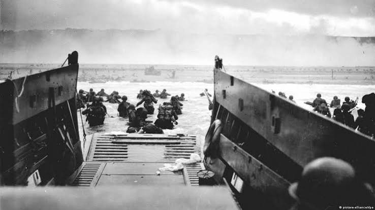
    Omaha Beach was different. The Americans faced the 352nd Infantry Division, a crack German unit that had been moved there for training. The naval bombardment, meant to soften the defenses, had missed many of the bunkers. As the landing craft opened their ramps, the men were met with a murderous crossfire from the bluffs above. The first waves were decimated. Many soldiers were killed before they could even reach the water. For hours, the landing seemed to be a disaster. But slowly, small groups of men—many of them from the 1st and 29th Infantry Divisions—managed to climb the bluffs and knock out the German positions. By nightfall, they had carved out a beachhead, but at a cost of over 2,400 casualties, the highest of any sector.

    The German Response

    The Germans were caught off guard. Rommel was in Germany celebrating his wife’s birthday; many senior officers were away from their posts. The initial reaction was confusion. Hitler, who had been asleep, was not awakened until late morning. When he finally authorized the release of the Panzer divisions, it was already too late. The reserves, held back for the expected invasion at Pas-de-Calais, were slow to move, and Allied air superiority made their journey to the beaches a deadly gauntlet. By the end of the day, the Allies had landed over 156,000 troops and established a foothold. The Atlantic Wall had been breached, but the battle for Normandy was far from over.

    The Human Cost

    D-Day’s success came at a terrible price. Allied casualties on June 6 are estimated at around 10,000, with over 4,400 confirmed dead. The Americans suffered the most, particularly at Omaha. German casualties are estimated between 4,000 and 9,000, but the true numbers are unknown. French civilians also paid a heavy toll. In the weeks leading up to the invasion, Allied bombing raids targeted roads, bridges, and railways, killing thousands of civilians. The town of Caen, a key objective, was almost completely destroyed, and its liberation would not come until July. For the French, the war was not just a distant struggle; it was a brutal reality that shattered their homes and lives.

    The Road to Victory

    The D-Day landings were not the end of the war, but they were the beginning of the end. The lodgment area in Normandy, though initially shallow, grew over the following weeks as the Allies fought through the hedgerows. The German army, though defending fiercely, was slowly pushed back. The liberation of Paris came in August, and by September, the Allies were on the German border. But the road was long and bloody. The Battle of the Bulge in December would prove that the Germans were still capable of a deadly counterattack. Yet D-Day had irrevocably changed the course of the war. It established a second front in Western Europe, forcing Germany to fight a two-front war against the Soviets in the east and the Western Allies in the west. The eventual defeat of Nazi Germany was now a matter of time.

    The Debate: Was D-Day Decisive?

    Historians have long debated the significance of D-Day relative to the Eastern Front. Some argue that the Soviet Union bore the brunt of the German war machine and that the Red Army’s victories were more decisive. Others contend that the Western Allied invasion, with its massive logistical and industrial power, was essential to breaking Germany’s ability to fight. The truth is that both fronts were crucial. D-Day opened a new theater that forced Germany to disperse its forces, and the Allied strategic bombing campaign—which had been crippling German industry and transportation—could now be supported by ground forces advancing toward the heart of the Reich. The invasion also had a profound psychological impact, demonstrating to the world that the Allies were committed to the liberation of Europe.

    The D-Day landings were a turning point, not just in military terms, but in the moral arc of the war. They were a demonstration of what free nations could achieve when they pooled their resources and their courage. The day’s heroism—from the paratroopers in the dark to the men struggling ashore on Omaha—has been immortalized in books, films, and memorials. But the true legacy of D-Day is not merely in the battle itself, but in the peace that followed. The invasion of Normandy was the first step toward the liberation of Western Europe and the eventual end of Nazi tyranny. It is a day that reminds us of the cost of freedom and the resolve required to defend it.

    Summary

    • Approximately 156,000 Allied troops landed on D-Day, supported by 11,000 aircraft and 7,000 naval vessels.
    • The operation involved five beach sectors: Utah, Omaha (U.S.), Gold, Sword (British), and Juno (Canadian).
    • A massive deception operation (Bodyguard) convinced the Germans that the invasion would come at Pas-de-Calais, not Normandy.
    • The bloodiest fighting was at Omaha Beach, where American forces suffered over 2,400 casualties.
    • Allied casualties on D-Day are estimated at 10,000, with 4,400 confirmed dead.

    FAQ

    Q: Why was Normandy chosen for the invasion instead of Pas-de-Calais?
    A: Normandy was chosen because it was within range of Allied fighter aircraft, had suitable beaches, and was less heavily fortified than Pas-de-Calais. The shorter crossing to Pas-de-Calais made it an obvious target, so the Germans built stronger defenses there. Normandy also offered the advantage of surprise, as the Allies’ deception campaign led the Germans to expect the main attack elsewhere.

    Q: What was the role of the French Resistance on D-Day?
    A: The French Resistance played a crucial role in the days before and after D-Day. They carried out acts of sabotage, cutting telephone lines, disrupting rail lines, and ambushing German convoys. They also provided valuable intelligence to the Allies about German troop movements. The BBC broadcast coded messages to coordinate these actions, with phrases like “the dice are on the table” signaling the start of the invasion.

    Q: How did the weather affect the invasion?
    A: The invasion was originally scheduled for June 5, but poor weather forced a 24-hour delay. Eisenhower’s decision to go on June 6 was based on a narrow weather window—a break in the storms that would allow the landings to proceed. The Germans, believing the weather was too rough for an invasion, were caught off guard, which contributed to the initial success of the landings.

    Q: What were the Mulberry harbors?
    A: The Mulberry harbors were artificial portable harbors built by the Allies to supply the invasion forces. They were constructed in England and towed across the Channel, then assembled off the Normandy coast. Two were built, one at Omaha Beach and one at Gold Beach, but the one at Omaha was destroyed by a storm on June 19. The remaining harbor was used for months to bring in troops, vehicles, and supplies.

    Q: How many casualties did the Allies suffer on D-Day?
    A: Allied casualties on D-Day are estimated at around 10,000, with 4,400 confirmed dead. The Americans suffered the most, with about 2,400 casualties at Omaha Beach alone. German casualties are estimated between 4,000 and 9,000, but the exact numbers are uncertain. Civilian casualties in Normandy were also significant, with many French citizens killed in the bombing and fighting.
  • The Civilian Road Map That Outmaneuvered the German Army on D-Day

    The Civilian Road Map That Outmaneuvered the German Army on D-Day

    On June 6, 1944, as Allied troops stormed the beaches of Normandy, they carried a secret weapon that had nothing to do with new tanks or code-breaking machines. It was a simple road map, designed for French motorists, published by the tire company Michelin. This map, No. 51 in Michelin’s series, covering the region from Caen to Le Mans, would prove to be one of the most effective intelligence assets of the entire campaign.

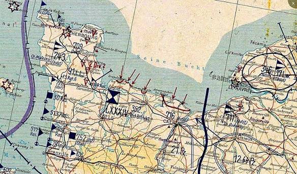
    The Germans had fortified the Atlantic Wall with concrete bunkers, millions of mines, and formidable artillery. But they had overlooked the humble road map. While German officers navigated with outdated military surveys, Allied commanders unfolded their Michelin maps and saw a detailed web of minor roads, farm tracks, and bridges that the German maps simply didn’t show. In the chaos of the Normandy bocage a maze of sunken lanes and earthen hedgerows this difference was decisive.

    A Map Made for Tourists, Not Soldiers

    Michelin began producing detailed road maps of France in 1900, not for military strategists but for the growing number of motorists who wanted to explore the countryside in their new automobiles. The company’s tire salesmen and local correspondents fed a constant stream of updates back to the mapmakers, ensuring that roads, bridges, and even isolated farms were accurately depicted. By the 1930s, these maps had become the gold standard for civilian travel in France.

    When the Second World War broke out, the British War Office recognized the potential military value of these maps. They quietly began stockpiling Michelin maps, and when France fell in 1940, they made sure to secure as many copies as possible. But the real champion of the Michelin map was Major David “Dai” Rees, a Welsh cartographer with the British Army’s Geographical Section, General Staff (GSGS).

    The Cartographer Who Saw the Obvious

    Major Rees was not a flamboyant intelligence officer. He was a meticulous mapmaker who understood that the official military maps of Normandy were woefully inadequate. Many were based on surveys from the 19th century, and they lacked the granular detail of minor roads and sunken lanes that would be crucial for troop movements in the bocage. Rees knew that the Michelin maps, with their up-to-date road networks, gradients, and even the locations of isolated farmhouses, were infinitely better.

    He faced bureaucratic resistance. Some officers dismissed the idea of using a commercial touring map for military operations. But Rees persisted, and his foresight paid off. The War Office reproduced the Michelin maps in huge numbers, classifying them as “GSGS 4249.” Hundreds of thousands of copies were printed on lightweight, color-coded paper that could be folded and stuffed into a soldier’s pocket.

    The Bocage: A Navigator’s Nightmare

    The terrain of Normandy was unlike anything the Allied troops had encountered. The bocage was a patchwork of small fields enclosed by thick, earthen hedgerows, often topped with trees and shrubs. Sunken lanes, worn down by centuries of use, crisscrossed the landscape. Tanks and infantry could easily get lost, and the hedgerows provided the Germans with excellent defensive positions. For the Allies, every advance required precise navigation.

    German forces, by contrast, were often operating with maps that lacked the same level of detail. They had not anticipated that the Allies would rely on a civilian commercial map, and they certainly did not expect the Allies to have such intimate knowledge of the minor road network. This gave the Allies a significant navigational advantage, especially in the months of brutal fighting that followed the initial landings.

    The Secret That Wasn’t

    The maps were not classified documents. The secrecy lay in the fact that the Allies were using them at all, and in the scale of the reproduction effort. The Germans could not conceive that a tire company’s product for motorists would become a critical military tool. It was a cartographic sleight of hand that took the enemy by surprise.

    After the war, Michelin’s role was officially acknowledged. The company was praised for its foresight in maintaining detailed, up-to-date maps of France. The maps, originally created to sell tires, had helped to liberate the country.

    The Michelin map of Normandy is a reminder that sometimes the most effective tools are not the most sophisticated. A civilian road map, designed for Sunday drives, gave the Allies a crucial edge in one of the most complex military operations in history. It was a triumph of commercial cartography applied to the grim business of war, and it saved countless lives.

    Summary

    • The Michelin road map No. 51 (covering Caen to Le Mans) was used extensively by Allied forces during D-Day and the Battle of Normandy.
    • The map provided detailed data on minor roads, bridges, and terrain features that official military maps lacked.
    • Major David “Dai” Rees, a British cartographer, championed the use of the Michelin maps, overcoming bureaucratic resistance.
    • The maps were mass-produced by the British War Office as “GSGS 4249” and distributed to hundreds of thousands of Allied troops.
    • The Germans were unaware that the Allies relied on a civilian commercial map, giving the Allies a significant navigational advantage in the bocage country.

    FAQ

    Q: Were the Michelin maps classified as ‘secret’ during the war?
    A: No, the maps themselves were not classified. The secrecy was in the fact that the Allies were using them at all, and in the scale of the reproduction effort.

    Q: Why were the official military maps of Normandy so poor?
    A: Many were based on outdated surveys, some dating back to the 19th century, and they lacked detail on minor roads and sunken lanes. Additionally, the French national mapping agency had been compromised by the Vichy regime, and some official maps were deliberately inaccurate.

    Q: How did the Allies get their hands on the Michelin maps?
    A: The British War Office stockpiled Michelin maps before the war, and additional copies were smuggled out of occupied France by resistance networks.

    Q: What made the Michelin maps better than military maps?
    A: They were updated frequently and included details like road widths, gradients, and the locations of isolated farms, making them far more accurate for navigation in the bocage.

    Q: Did the Germans ever figure out that the Allies were using Michelin maps?
    A: There is no evidence they did. The Germans did not anticipate that the Allies would rely on a civilian commercial map, and the Allies’ detailed knowledge of minor roads took them by surprise.

  • The Double-Cross System: How Britain Turned Nazi Spies into Its Greatest Weapon

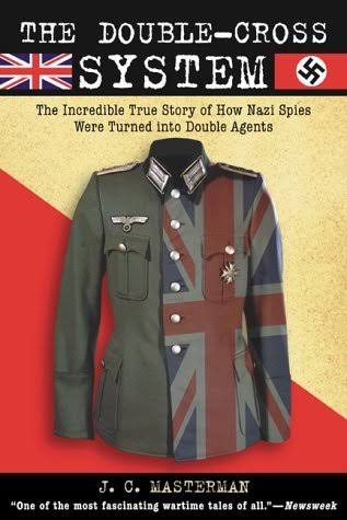
    The Double-Cross System: How Britain Turned Nazi Spies into Its Greatest Weapon

    In the spring of 1944, as the Allies prepared for the invasion of Normandy, a Spanish double agent code-named Garbo sat in a London safe house, crafting a message that would help decide the fate of Europe. For years, he had been feeding the German Abwehr a stream of carefully fabricated intelligence from a network of fictitious sub-agents a network that existed only in his imagination. Now, on the eve of D-Day, his lies would convince Hitler that the real invasion was coming at Pas-de-Calais, not Normandy. The Germans trusted him so completely that they awarded him the Iron Cross. The British, for their part, gave him an MBE.

    Garbo was just one of dozens of Nazi agents who, after being captured or turning themselves in, became unwilling or sometimes willing allies of MI5. The Double-Cross System, as it was called (the Roman numeral XX, a pun on ‘double cross’), was a counter-espionage operation that flipped nearly every German spy sent to Britain during World War II. Of the roughly 115 to 120 agents dispatched by the Abwehr, all were captured or surrendered. None operated freely for any significant time. Instead, MI5 used them to feed false intelligence back to Germany, shaping the enemy’s strategic decisions and ultimately saving thousands of Allied lives.

    The Birth of a Deception

    Before the war, MI5 was a small, underfunded organization focused on domestic subversion Soviet espionage and Irish republicanism not on running double agents. It had little experience with such operations, and the idea of turning enemy spies into assets was untested. But the early war years forced a change.

    The turning point came in 1939 with a Welsh electrical engineer named Arthur Owens, code-named ‘Snow.’ Owens, a German agent, walked into MI5 and offered his services. He became the first major double agent, and his case proved that a captured or volunteer agent could be used to feed false information back to the Abwehr. Snow’s success led to a more systematic approach.

    In January 1941, the Twenty Committee was formally established to coordinate the growing number of double agents. Chaired by Sir John Masterman, a historian and MI5 officer, the committee met weekly. Its members included representatives from MI5, MI6, the armed services, and the Home Defence Executive. The committee’s name Twenty, or XX was a Roman numeral pun on ‘double cross.’ Its goal: to ensure that every double agent’s messages to Germany were carefully crafted to deceive the enemy, not inform them.

    The Agents: A Rogue’s Gallery

    The Double-Cross System relied on a colorful cast of characters, each with their own reasons for betraying their German handlers.

    Garbo (Juan Pujol García) was a Spanish double agent who invented an entire network of fictitious sub-agents. His misinformation helped convince the Germans that the D-Day landings at Normandy were a diversion. He was awarded both the Iron Cross (by Germany) and an MBE (by Britain).

    Zigzag (Eddie Chapman) was a British criminal and safecracker who volunteered to work for Germany, then turned himself in to MI5 upon returning to Britain. He was used to feed false intelligence about bombing damage, convincing the Germans that their V-1 and V-2 attacks were causing more destruction than they actually were.

    Tate (Wulf Schmidt) was a Danish agent who was captured and doubled. He maintained a consistent radio link with Germany for years, sending a steady stream of false reports that helped convince the Germans that British morale was low and that the country was on the brink of collapse.

    Mutt and Jeff (John Moe and Tor Glad) were two Norwegian agents who were doubled and used to convince Germany that Britain was preparing for an invasion of Norway part of Operation Fortitude North, the northern half of the D-Day deception.

    Tricycle (Duško Popov) was a Serbian playboy and lawyer who, while working as a double agent, alerted the FBI to German interest in Pearl Harbor. His warning was largely ignored, but his work for the British was invaluable.

    The Indispensable Partner: Bletchley Park

    The Double-Cross System could not have worked without the intelligence gleaned from Bletchley Park’s decryption of German Enigma traffic. Ultra, as it was called, allowed British intelligence to read Abwehr radio messages and verify what the Germans believed. This meant MI5 could confirm that their double agents were trusted, and calibrate the false information accordingly. Without Ultra, the Double-Cross System would have been flying blind.

    For example, when Garbo sent a message to Germany, the British could read the Abwehr’s response and see whether they bought his story. If they hesitated, MI5 could adjust the next message to reinforce their trust. This feedback loop made the deception nearly perfect.

    The Greatest Deception: Operation Fortitude

    The Double-Cross System’s crowning achievement was Operation Fortitude, the deception that preceded D-Day. The Allies needed to convince the Germans that the invasion would come at Pas-de-Calais, the closest point to England, rather than at Normandy. To do this, they created a fictional army—the First U.S. Army Group (FUSAG)—under General George S. Patton.

    Double agents, including Garbo, reported on the supposed movements of FUSAG, building a picture of an invasion force poised to strike at Calais. Garbo’s network of fictitious agents sent detailed reports—complete with sightings of troops, vehicles, and equipment—that the Germans found entirely credible. They even reported that the Normandy landings were a diversion, designed to draw forces away from the real invasion.

    Hitler fell for it. He kept German forces in the Pas-de-Calais region for weeks after the Normandy landings, convinced that the main attack was still coming. This delay gave the Allies a crucial advantage in establishing their beachhead and breaking out into France.

    The Legal and Moral Grey Zone

    The Double-Cross System operated in a legal grey area. Under the laws of war, captured enemy agents were liable to execution. By doubling them, MI5 spared their lives in exchange for cooperation. But not all agents cooperated. Some refused and were executed. Others were deemed too dangerous to keep alive, even after they had provided useful information. The British public was never told about the system during the war.

    The morality of using captured spies was debated at the time, but the results were undeniable. The system saved countless lives by reducing the effectiveness of German intelligence and enabling the success of D-Day.

    A Legacy of Success

    The Double-Cross System is widely regarded as one of the most successful deception operations in military history. It shaped German strategic assessments, misled them about Allied intentions, and contributed significantly to the Allied victory. The agents themselves, many of whom were criminals, traitors, or opportunists, became unlikely heroes of a war that demanded extraordinary measures.

    The Double-Cross System was a testament to the power of deception in warfare. By turning the enemy’s own spies against them, British intelligence not only neutralized the threat of German espionage but also used it as a weapon to win the war. The story of Garbo, Zigzag, Tate, and the others is a reminder that in war, truth is the first casualty—but sometimes, a well-crafted lie can save a nation.

    Summary

    • The Double-Cross System (XX System) was a British counter-espionage operation that flipped captured German agents into double agents, feeding false intelligence to the Abwehr.
    • Of the 115-120 German agents sent to Britain during WWII, all were captured or surrendered; about 40-50 were doubled.
    • Key agents included Garbo (Juan Pujol García), Zigzag (Eddie Chapman), Tate (Wulf Schmidt), Mutt and Jeff (Norwegian agents), and Tricycle (Duško Popov).
    • The Twenty Committee, chaired by Sir John Masterman, coordinated the operation, with crucial support from Bletchley Park’s Ultra decrypts.
    • The system played a central role in Operation Fortitude, convincing Hitler that D-Day would come at Pas-de-Calais, not Normandy, and aiding the Allied victory.

    FAQ

    Q: What was the Double-Cross System?
    A: The Double-Cross System (XX System) was a British intelligence operation during World War II that identified, captured, and ‘turned’ German agents in Britain, using them to feed false information back to Nazi Germany’s intelligence services.

    Q: How many German agents were doubled?
    A: Of the roughly 115-120 German agents sent to Britain, all were captured or turned themselves in. Approximately 40-50 were used for deception; the rest were executed or imprisoned.

    Q: Who was Garbo?
    A: Garbo was Juan Pujol García, a Spanish double agent who invented a fictitious network of sub-agents. His misinformation helped convince the Germans that the D-Day landings at Normandy were a diversion. He was awarded both the Iron Cross and an MBE.

    Q: How did Bletchley Park help the Double-Cross System?
    A: Bletchley Park’s decryption of German Enigma traffic (Ultra) allowed MI5 to read Abwehr messages, verify that their double agents were trusted, and calibrate false information accordingly.

    Q: What was Operation Fortitude?
    A: Operation Fortitude was the D-Day deception that convinced the Germans that the Allied invasion would land at Pas-de-Calais, not Normandy, using a fictional army (FUSAG) under General Patton. The Double-Cross System was central to this deception.