Tag: biodiversity

  • The Flooded Forests of Congaree: How a River Sustains Record-Breaking Trees

    The Flooded Forests of Congaree: How a River Sustains Record-Breaking Trees

    Deep in central South Carolina, a river breathes. About ten times a year, the Congaree River swells over its banks and spreads across a 26,000-acre floodplain, submerging up to 80% of the land under a shallow, nutrient-rich sheet of water. This isn’t a disaster it’s a life-giving pulse that sustains one of the last old-growth bottomland hardwood forests in the Southeast.

    Congaree National Park, just 20 miles southeast of Columbia, holds trees that stretch over 150 feet into the sky. Loblolly pines, sweetgums, and cherrybark oaks here are record-breakers the largest known individuals of their species in the United States. The secret to their towering success lies not in the soil, but in the floodwaters that periodically wash over them.

    A Forest That Dances with the River

    Most forests rely on rain and soil for their nutrients. Congaree has a different partner: the Congaree River. As it meanders across the Atlantic Coastal Plain, the river carries silt and clay eroded from the Piedmont. When it floods, it deposits this alluvium across the floodplain, fertilizing the land like a natural compost spread. This constant renewal is why the trees grow so fast and so tall.

    Ecologists call this relationship the “flood pulse concept.” It’s a simple idea: the periodic rise and fall of river water is the main driver of life in a floodplain. The floodwaters don’t just add nutrients; they also carry fish and aquatic invertebrates into the forest, where they feed and spawn in the temporary shallows. When the water recedes, it leaves behind mudflats where fast-growing plants quickly germinate. The timing, duration, and depth of each flood determine which species thrive in which zone of the floodplain.

    Three Neighborhoods, One Forest

    Walk from the river’s edge inland, and you’ll pass through distinct neighborhoods, each shaped by how often it floods.

    Levee forests sit on the natural embankments built up by centuries of sediment deposits. These high spots flood only occasionally, so they support drier-loving species like sweetgum, water oak, and loblolly pine. The loblolly pines here are the giants—some exceed 150 feet, making them national champions.

    Bottomland hardwood forests occupy the middle ground. They flood a few times a year, so they host species that can tolerate wet feet: cherrybark oak, swamp chestnut oak, and American beech. These trees are also record-setters, with cherrybark oaks reaching heights that rival the pines.

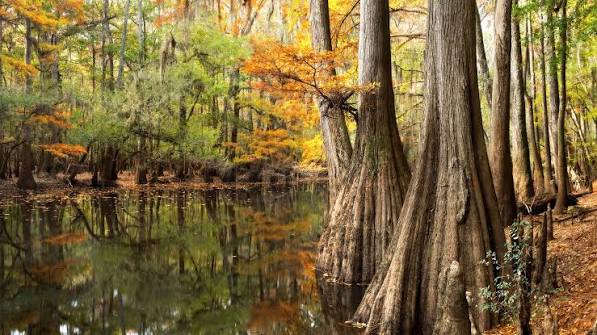
    Swamp forests are the lowest zones, where water stands for much of the year. Here, bald cypress and water tupelo dominate. Their trunks flare at the base, and their roots form “knees” that stick up out of the water—structures that help anchor them in the soft, wet soil and may aid in gas exchange.

    The Birth of Oxbow Lakes

    The river that feeds this forest is a restless wanderer. It constantly erodes its outer banks and deposits sediment on its inner curves, causing its meanders to migrate over time. Occasionally, a meander loop becomes so tight that the river breaks through its narrow neck during a flood, cutting off the old loop. That abandoned curve becomes an oxbow lake—a crescent-shaped, still-water channel.

    Congaree has several oxbow lakes, including Weston Lake and Muck’s Lake. They start as open water, but as they slowly fill with organic matter and sediment, they transition into swampy wetlands, and eventually into forested areas. This ecological succession is visible across the park, with old oxbows now supporting mature forests.

    Biodiversity in a Watery World

    Despite its frequent flooding—or perhaps because of it—Congaree is a biodiversity hotspot. The park hosts over 75 tree species and more than 900 vascular plant species. It’s also home to a rich array of wildlife: river otters, bobcats, and the endangered red-cockaded woodpecker, which nests in the park’s mature pines. The state-endangered swallow-tailed kite soars overhead, and the floodplain’s temporary pools teem with amphibians and reptiles.

    One of the best ways to see this life is from a canoe. Cedar Creek, a blackwater tributary, winds through the park and offers a quiet, close-up view of the swamp forests and their inhabitants.

    A History of Survival

    Congaree’s old-growth forest is a rare survivor. In the early 20th century, most bottomland hardwood forests in the Southeast were clear-cut for timber. Congaree was spared largely because its frequent flooding made logging difficult and expensive. The trees stood tall, but the threat didn’t pass. In the 1960s and 1970s, a proposed clear-cut sparked a grassroots campaign to save the forest. Their efforts paid off: the area was designated a national monument in 1976, a UNESCO Biosphere Reserve in 1983, and finally a national park in 2003.

    Today, visitors can explore this living museum via a 2.4-mile boardwalk that loops through the floodplain. When the river is low, the boardwalk offers dry passage; during floods, it becomes a floating dock above the water. For a more immersive experience, kayakers can paddle the park’s waterways, gliding between cypress knees and beneath canopies of ancient trees.

    Congaree National Park is more than just a collection of tall trees. It’s a testament to the power of natural processes—floods, meanders, and succession—working together to create an ecosystem of extraordinary richness. Its survival is a reminder that protecting wild places means protecting the dynamic forces that shape them. The next time the Congaree River rises, it’s not a threat; it’s the forest’s heartbeat.

    Summary

    • Congaree National Park is one of the last old-growth bottomland hardwood forests in the Southeast, covering 26,000 acres in South Carolina.
    • The Congaree River floods about 10 times a year, depositing nutrient-rich silt that sustains record-breaking tree growth.
    • The park features distinct forest zones—levee, bottomland, and swamp—each adapted to different flood frequencies.
    • Oxbow lakes, formed when river meanders are cut off, are scattered across the landscape and show ecological succession.
    • The park is home to over 75 tree species and diverse wildlife, including endangered species like the red-cockaded woodpecker.
    • Congaree was saved from logging due to frequent floods and later protected, becoming a national park in 2003.

    FAQ

    Q: What makes Congaree’s trees so large?
    A: The periodic flooding of the Congaree River deposits nutrient-rich silt and clay (alluvium) across the floodplain, fertilizing the soil. This natural fertilization, combined with a long growing season, allows trees to grow exceptionally tall and fast.

    Q: How often does Congaree flood?
    A: On average, the river floods about 10 times per year, sometimes covering up to 80% of the park. The timing and depth of floods vary seasonally and annually.

    Q: What is an oxbow lake?
    A: An oxbow lake forms when a river meander loop is cut off during a flood, leaving a crescent-shaped, still-water channel. Over time, it fills with sediment and organic matter, eventually becoming a wetland or forest.

    Q: Can visitors see the floodplain without a boat?
    A: Yes, a 2.4-mile elevated boardwalk lets visitors walk through the floodplain during dry periods. During floods, the boardwalk may be partially underwater, but a canoe or kayak can still be used.

    Q: Why is Congaree important for wildlife?
    A: The floodplain provides a rich habitat for many species, including endangered ones like the red-cockaded woodpecker and swallow-tailed kite. Floodwaters also support fish and aquatic invertebrates that move into the forest to feed and spawn.
  • Butterflies Are on the Move as the Planet Warms: What New Research Reveals

    Butterflies Are on the Move as the Planet Warms: What New Research Reveals

    When the temperature climbs, butterflies don’t argue they pack up and leave. New research using decades of citizen-science data shows that dozens of butterfly species are shifting their ranges poleward and uphill at rates of 35–40 kilometers per decade. But not all butterflies are keeping pace, and the ones that lag behind are paying a price.

    This isn’t just a curiosity of the insect world. Butterflies are among the most sensitive indicators of climate change, and their movements are reshaping ecosystems, challenging conservation strategies, and offering a window into what’s happening to biodiversity everywhere.

    A Climate Race with Winners and Losers

    In the UK, the brown argus and the comma butterfly have pushed their ranges northward by over 100 kilometers in recent decades. Across the Atlantic, the sachem skipper and giant swallowtail are now showing up in states where they were once unknown. In Europe, the map butterfly has crossed the English Channel into southern England.

    These movements are not random. They follow temperature gradients. As the planet warms, the ‘thermal envelope’—the range of temperatures a species can tolerate—shifts toward the poles and up mountainsides. Butterflies, being cold-blooded, feel these changes acutely.

    The average shift is about 35–40 km per decade, but the variation is enormous. Some species are sprinting; others are barely crawling. The difference often comes down to biology: how fast a species can fly, how many generations it produces per year, and how picky it is about its habitat. Fast movers like the comma butterfly are generalists that can breed quickly. Slow movers, often habitat specialists, get stuck when the landscape is fragmented by farms, roads, and cities.

    This creates a stark divide between ‘winners’ and ‘losers’ in the climate race.

    The Elevation Squeeze

    In mountainous regions, the story is even more dramatic. Montane species like the Apollo butterfly in the Alps are moving upward at rates of 100–300 meters per decade. But there’s a limit to how high they can go.

    When a butterfly reaches the summit, there’s nowhere left to climb. Populations get marooned on ‘islands in the sky,’ and as the climate continues to warm, these islands shrink. Scientists call this ‘mountaintop extinction,’ and it’s already happening to some high-elevation specialists.

    The physics of temperature is unforgiving: a 1°C warming pushes the thermal envelope about 150 meters up a mountain, but the mountain doesn’t get taller. For species that are adapted to cold, the future is a shrinking ladder.

    The Problem of Climate Debt

    Here’s the uncomfortable truth: even the fastest-moving butterflies aren’t keeping up with the pace of climate change. In temperate regions, temperature zones are shifting at an estimated 40–50 km per decade. That’s faster than most butterflies can fly.

    This gap between where a species is and where it should be is called ‘climate debt.’ Many butterfly populations are already living in conditions that are slightly too warm for them. They survive, but they’re stressed. Their reproduction drops, their immune systems weaken, and they become more vulnerable to extreme weather events like heatwaves and droughts.

    A recent study in Global Change Biology found that in the UK, over a third of butterfly species have accumulated significant climate debt. These are species that are slowly being left behind in the race to cooler climes.

    Why Butterflies Are the Perfect Canaries

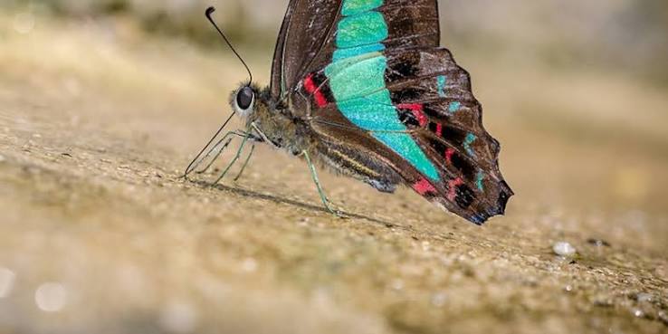
    Butterflies are ectothermic—their body temperature is largely determined by their surroundings. They can’t shiver or sweat. So when temperatures rise, they must either move, adapt, or die. Their short generation times mean they respond to climate change rapidly, making them early warning signals for other species.

    But it’s not just their biology that makes them useful. Butterflies have been observed and recorded by amateur naturalists for over a century. The UK Butterfly Monitoring Scheme has over 50 years of continuous data, and the North American Butterfly Association counts draw on thousands of volunteer hours. This wealth of data allows scientists to track range shifts with remarkable precision.

    Butterflies are the ‘canaries in the coal mine’ for biodiversity, and right now, they’re singing loudly.

    Rethinking Conservation

    Traditional conservation has been static: you identify a patch of habitat and protect it. But as butterflies move, they’re leaving protected areas behind. A reserve might protect a southern population that’s dying out, while the species’ future lies in unprotected land to the north.

    This has sparked a paradigm shift toward ‘climate-smart conservation.’ The idea is to plan for movement, not just for current occupancy. That means creating connectivity corridors that allow species to traverse fragmented landscapes. It means identifying climate refugia—areas like north-facing slopes or shaded valleys that stay cool even as the planet warms—and protecting those as future sanctuaries.

    It also means considering assisted migration: deliberately moving species to new habitats where they can survive. This is controversial, as it risks introducing species to ecosystems where they might become invasive, but for butterflies that are otherwise doomed, it may be the only option.

    Policy is beginning to catch up. The Global Biodiversity Framework agreed in Montreal in 2022 includes targets for connectivity and climate resilience. The EU’s Biodiversity Strategy for 2030 calls for a Trans-European Nature Network that accounts for species movement. But implementation is lagging.

    The Shuffling of Communities

    As butterflies move at different rates, ecological communities are being torn apart and reassembled in novel ways. A butterfly that used to rely on a particular plant for food might arrive in a new area where that plant is absent. Or it might arrive before its food source does, creating a phenological mismatch.

    These shifts ripple through ecosystems. Butterflies are pollinators, but they’re also prey for birds and other insects. When they move, the whole food web shifts with them. The result is a reshuffling of nature that we’re only beginning to understand.

    Conclusion

    Butterflies are telling us something urgent about the state of our planet. Their movements are a visible, measurable signal of climate change in action. Some species are adapting, but many are falling behind, and the ecosystems they inhabit are transforming in ways we can’t fully predict.

    The good news is that we have the tools to act. By creating connected landscapes, protecting climate refugia, and rethinking our conservation strategies, we can give butterflies—and the countless other species they represent—a fighting chance in a warming world.

    But the clock is ticking, and the butterflies are already on the move.

    Summary

    • Butterflies are shifting their ranges poleward at 35–40 km per decade and uphill at 100–300 meters per decade due to climate change.
    • Some species are moving fast, others are not moving at all, creating winners and losers in the climate race.
    • Many butterflies are accumulating ‘climate debt’ because they can’t keep up with the pace of warming.
    • Butterflies are indicator species, and their movements signal broader ecological changes.
    • Conservation must shift from static protected areas to ‘climate-smart’ strategies like connectivity corridors and climate refugia.

    FAQ

    Q: Why are butterflies moving north?
    A: Butterflies are cold-blooded, so their body temperature depends on their environment. As global temperatures rise, they seek out cooler conditions by moving toward the poles or to higher elevations.

    Q: How fast are butterflies moving?
    A: On average, butterfly ranges are shifting poleward at about 35–40 km per decade, though some species move much faster or slower. Mountain species are also moving upward at 100–300 meters per decade.

    Q: What is ‘climate debt’?
    A: Climate debt is the gap between where a species currently lives and where it needs to be to stay within its preferred temperature range. Many butterflies are accumulating this debt because they can’t move fast enough.

    Q: What is ‘mountaintop extinction’?
    A: It’s when high-elevation species like the Apollo butterfly are pushed to the top of mountains by warming and run out of habitat. They have nowhere else to go, leading to local or even global extinction.

    Q: How can conservation help butterflies adapt?
    A: Conservation can help by creating corridors that connect habitats, protecting climate refugia (cool, stable areas), and in some cases, assisted migration—moving species to new suitable areas. These strategies are part of ‘climate-smart conservation.’

  • Amazon vs. Congo: Which Rainforest Is Truly Wilder?

    What goes on the massive Congo Rainforest Basin? Has it been fully explored? What mysteries lie within it? : r/geography

    When you picture a ‘wild’ jungle, do you see the Amazon’s canopy teeming with jaguars and macaws, or the Congo’s misty depths where okapis and bonobos roam? Both are legendary, but they offer very different flavors of wildness. The Amazon is a biodiversity powerhouse, while the Congo is a vast, mysterious frontier that remains surprisingly untouched. Let’s compare them across size, species, human impact, and raw wilderness.

    The Amazon: Colossus of Biodiversity

    Spanning 5.5 million square kilometers across nine South American countries, the Amazon is the largest tropical rainforest on Earth. It holds roughly 390 billion individual trees across 16,000 species. That’s more tree species than the Congo has in its entire forest. The Amazon also boasts 1,300 bird species, 430 mammals, and an estimated 2.5 million insect species. This staggering diversity is partly due to its ancient lineage—rainforest conditions have existed for 55 million years—and the Andes’ rise 10 million years ago, which created varied habitats and drove speciation.

    But the Amazon isn’t just big; it’s also deeply modified by humans. Indigenous peoples have lived there for at least 13,000 years, and recent discoveries of ‘dark earth’ (terra preta) suggest populations of 8–10 million before Europeans arrived. So, much of what looks ‘pristine’ is actually a human-shaped garden. Today, cattle ranching drives 80% of deforestation, with about 8,000 km² lost annually—down from a peak of 27,000 km² in 2004, but still significant.

    The Congo: The Understudied Giant

    Central Africa’s Congo Basin is the second-largest rainforest, covering 1.8 million km²—about 18% of the world’s remaining tropical forest. It’s smaller, but in many ways, it’s wilder. Only about 20% of the Congo’s forests are considered disturbed, compared with 40% in the Amazon. Fewer roads, lower population density, and less industrial agriculture mean large swaths remain inaccessible.

    The Congo’s biodiversity is lower in absolute numbers—roughly 10,000 plant species (3,000+ endemic), 400 mammals, and 1,000 birds—but its endemism is remarkable. The okapi, bonobo, and Congo peacock are found nowhere else. Its isolation and ancient river system, which is the world’s deepest at 220 meters, have fostered unique evolutionary paths. However, the Congo is far less studied; scientists regularly discover new species there, so its true richness is likely underestimated.

    Deforestation: Different Drivers, Different Futures

    The Amazon’s deforestation is largely industrial: cattle ranching, soy, and illegal gold mining. The Congo’s is more about survival: smallholder slash-and-burn agriculture, charcoal production, and artisanal mining for coltan and cobalt. Annual deforestation in the Congo is about 12,000 km²—higher than the Amazon’s current rate—but it’s driven by different pressures. The Congo also contains the world’s largest tropical peatland (145,000 km²), storing 30 billion tons of carbon. Oil exploration in places like Virunga National Park threatens this carbon vault.

    Which Is Wilder? It Depends How You Define ‘Wild’

    If ‘wild’ means raw biodiversity, the Amazon wins—it has 5–10 times more tree species and overall higher species richness. But if ‘wild’ means untouched by human hands, the Congo takes the crown. Its forests are less fragmented, and its indigenous Pygmy peoples (Baka, Mbuti) have lived there for 50,000 years with a lighter footprint. The Amazon’s ‘wildness’ is partly an illusion—it’s a human-shaped landscape. The Congo’s wildness is more authentic, even if smaller.

    The Verdict: Two Kinds of Wild

    There’s no single ‘wilder’ jungle—they’re wild in different ways. The Amazon is a biodiversity giant, a living laboratory of evolution. The Congo is a deep, dark frontier, less studied and less disturbed. Both face existential threats from climate change and resource extraction. Appreciating their unique wildness is the first step to protecting them.

    Next time someone asks which jungle is wilder, ask them what they mean. If they want the most species, it’s the Amazon. If they want the least human impact, it’s the Congo. Both are irreplaceable, and both need our attention.

    Summary

    • Amazon: 5.5M km², 16,000 tree species, ~1,300 birds, 430 mammals; higher biodiversity but 40% disturbed.
    • Congo: 1.8M km², ~10,000 plants, 400 mammals, 1,000 birds; higher endemism per area, only 20% disturbed.
    • Deforestation drivers: Amazon – cattle/soy; Congo – smallholder agriculture/charcoal.
    • Wildness: Amazon = biodiversity; Congo = inaccessibility and lower human modification.
    • Congo’s peatland: 145,000 km² storing 30 billion tons of carbon—critical for climate.

    FAQ

    Q: Which rainforest has more animal species?
    A: The Amazon has more in absolute numbers—1,300 birds and 430 mammals vs. Congo’s 1,000 birds and 400 mammals—but the Congo has a higher percentage of endemic species.

    Q: Is the Congo River deeper than the Amazon?
    A: Yes, the Congo is the world’s deepest river at up to 220 meters, while the Amazon’s max depth is around 100 meters.

    Q: Which forest is more threatened?
    A: Both are threatened, but differently. The Amazon faces industrial deforestation (cattle/soy), while the Congo faces slash-and-burn and charcoal, plus emerging oil exploration.

    Q: Are there uncontacted tribes in both?
    A: The Amazon has ~50 uncontacted tribes; the Congo has indigenous Pygmy groups like the Baka and Mbuti, but they are more integrated.

    Q: Which is bigger?
    A: The Amazon is about three times larger (5.5M km² vs. 1.8M km²).