Tag: air pollution

  • Why Indonesia’s Peat Fires Burn for Months and How They Darken Skies

    Why Indonesia’s Peat Fires Burn for Months and How They Darken Skies

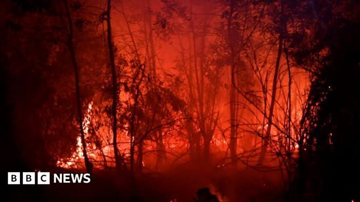
    When images of orange skies and smoke-blanketed cities emerge from Indonesia, they often signal the return of a recurring crisis: peatland fires. In recent months, satellite data from NASA FIRMS has detected thousands of fire hotspots on the islands of Sumatra and Kalimantan, with provinces like Riau, South Sumatra, Central Kalimantan, and West Kalimantan particularly affected. The fires are not your typical forest blazes they burn both above and below ground, making them notoriously difficult to extinguish and capable of smoldering for weeks or even months.

    This isn’t just an Indonesian problem. The resulting haze has pushed air quality to hazardous levels in cities like Palangkaraya, where PM2.5 concentrations have exceeded an AQI of 300, forcing schools to close and disrupting flights. The smoke also carries health risks across Southeast Asia, affecting millions in neighboring countries. Understanding why these fires happen, why they persist, and what can be done is essential for anyone concerned about climate change, public health, or the future of tropical ecosystems.

    The Hidden Fuel Beneath the Forest

    To grasp why peat fires are so severe, you need to know what peat is. Imagine a sponge made of partially decomposed leaves, wood, and other plant material, soaked in water. That’s peat. It forms over thousands of years in waterlogged areas where dead vegetation doesn’t fully rot because there’s little oxygen. Indonesia holds about 36% of the world’s tropical peatlands, which store an estimated 35 to 60 billion metric tons of carbon—that’s a massive amount of carbon locked away.

    When peatlands are drained for agriculture, usually through networks of canals, the water is removed. The once-spongy peat dries out and becomes extremely flammable. It’s like turning a wet sponge into tinder. And once ignited, the fire can creep underground, burning through the peat layer itself. These ground fires are notoriously difficult to put out because water and fire retardants often can’t reach the deep layers. They can smolder for weeks, releasing enormous amounts of smoke and carbon dioxide.

    Why Do These Fires Start?

    The immediate cause is often human activity. In Indonesia, fire is frequently used as a cheap and quick way to clear land, especially for palm oil and pulpwood plantations. Despite many large companies adopting ‘zero-burning’ policies, smallholders and illegal land clearers still rely on burning because it’s the most cost-effective method for them. Accidental ignitions from discarded cigarettes or campfires also play a role. During the dry season, particularly when an El Niño event reduces rainfall, the dried peat becomes even more combustible. This combination—dried peat, human ignition, and drought—creates the perfect storm.

    Historical patterns show that severe fire years often coincide with strong El Niño events. The 1997-98 fires were catastrophic, and the 2015 fire season was one of the worst on record, at one point emitting more CO2 daily than the entire U.S. economy. The 2015 fires were linked to over 100,000 premature deaths from smoke inhalation across Southeast Asia, according to estimates from Harvard and Columbia researchers. More recently, 2019 also saw significant fires. The current event, while still unfolding, appears to be following a similar trajectory.

    Smoke That Chokes: Health and Air Quality

    The most visible impact of peat fires is the thick, acrid haze that darkens skies and reduces visibility. This smoke is not just unpleasant—it’s a serious health hazard. It contains fine particulate matter, known as PM2.5, which can penetrate deep into the lungs and enter the bloodstream. When PM2.5 levels reach hazardous levels, as they have in several Indonesian cities, it triggers a range of health problems, from respiratory infections to heart disease and strokes. Children, the elderly, and those with pre-existing conditions are especially vulnerable.

    During the 2015 fires, schools closed, and airports shut down due to poor visibility, disrupting travel and daily life. The economic costs are staggering: healthcare burdens, lost productivity, and damage to tourism and agriculture. In 2019, the Indonesian government estimated economic losses in the billions of dollars. The haze also has transboundary effects, regularly straining relations with Malaysia and Singapore, which have repeatedly called for action to stop the annual smoke.

    Climate Consequences: A Vicious Cycle

    Peat fires are a major source of greenhouse gas emissions. When peat burns, it releases not only carbon dioxide but also methane, a potent greenhouse gas. The 2015 fires alone released an estimated 1.75 billion tons of CO2 equivalent, according to the World Resources Institute. That’s more than the annual emissions of Germany or Japan. These emissions accelerate climate change, which in turn can worsen droughts, making peat fires more likely. It’s a vicious cycle: fires contribute to climate change, and climate change creates conditions that make fires worse.

    Beyond carbon, peat fires destroy critical habitat for endangered species like orangutans and Sumatran tigers. The fires also degrade the peatland ecosystem, leaving it more vulnerable to future fires and flooding. The restoration process is slow—it can take decades for peat to re-accumulate and for the ecosystem to recover.

    What’s Being Done About It?

    The Indonesian government has taken steps to address the problem. A moratorium on new peatland development was established, and in 2016, the Peatland Restoration Agency (BRG) was set up to coordinate restoration efforts. These initiatives include blocking canals to rewet peatlands and promoting alternative farming methods that don’t rely on burning. However, enforcement is challenging. The economic pressure to expand palm oil and pulpwood plantations is strong, and many smallholder farmers have no affordable alternative to slash-and-burn.

    International pressure, such as the European Union’s deforestation regulation, aims to ensure that products sold in the EU are not linked to deforestation. This could push companies to be more responsible about their supply chains. But the problem is deeply rooted in local livelihoods and governance. As the journalist and environmentalist Satrio Nuswantoro puts it, ‘You can’t just ban fire; you have to offer an alternative that makes sense economically for farmers.’

    Looking Ahead: The Need for Sustainable Solutions

    Addressing peatland fires requires a multi-pronged approach. On the ground, efforts to rewet drained peatlands are crucial. Restoring water levels prevents the peat from drying out and becoming flammable. For communities, providing accessible alternatives to fire—such as mechanical land clearing or agroforestry systems—can reduce intentional burning. Better enforcement and monitoring using satellite data can help catch fires early, though this is only effective if there’s the capacity to respond quickly.

    Long-term, climate change mitigation is key. Reducing global emissions will lessen the severity of El Niño events and droughts, indirectly reducing fire risk. But for now, as long as peatlands remain drained and dry, the threat of fires will persist. Each fire season, we’re reminded that the health of our planet is tied to the health of these ancient, carbon-rich landscapes. Protecting them isn’t just Indonesia’s responsibility; it’s a global imperative.

    Peatland fires in Indonesia are a complex disaster with roots in land use, poverty, and climate change. They burn for months because they smolder underground, releasing toxic smoke and massive amounts of carbon. While Indonesia has made efforts to restore degraded peatlands, the challenge is immense. The fires that darken skies in Sumatra and Kalimantan are also darkening the future of our climate. Solving this will require not just policy changes but also support for communities to adopt sustainable livelihoods. Otherwise, we’ll continue to see the same orange skies year after year.

    Summary

    • Indonesia’s peatland fires burn both above and below ground, making them extremely hard to extinguish.
    • Drainage of peat for agriculture turns it into highly flammable fuel, and fires are often started by humans.
    • Severe fire years are linked to El Niño-induced droughts, as seen in 2015 and 2019.
    • Smoke from fires causes hazardous air quality, leading to health crises and economic losses.
    • Restoration efforts and sustainable land management are key to preventing future fires.

    FAQ

    Q: Why do peat fires keep happening in Indonesia?nA: The underlying cause is drained peatlands, which dry out and become highly flammable. When land is cleared for agriculture, often using fire, the dried peat can ignite and burn underground for long periods. Droughts associated with El Niño make the peat even drier and more susceptible to fires.nnQ: What are the main health risks from the haze?nA: The haze contains fine particles (PM2.5) that can penetrate deep into the lungs, causing respiratory issues, heart disease, and other illnesses. Vulnerable groups like children and the elderly are particularly at risk. Long-term exposure can lead to chronic health problems.nnQ: How do peat fires affect climate change?nA: Peat fires release huge amounts of carbon dioxide and methane, which are potent greenhouse gases. For example, the 2015 fires emitted about 1.75 billion tons of CO2 equivalent, more than the annual emissions of many countries. This accelerates global warming, which in turn can make fires more likely.nnQ: What can be done to stop the fires?nA: Restoring water levels in drained peatlands is key, as wet peat won’t burn. Providing alternative livelihoods for farmers so they don’t need to clear land with fire, and enforcing regulations against illegal burning are also important. International pressure and support for sustainable palm oil production can help.nnQ: Is the current fire season worse than previous ones?nA: The severity varies each year. It’s important to check up-to-date data from sources like Indonesia’s Ministry of Environment and Forestry or NASA FIRMS. Historically, the 2015 and 2019 fires were particularly severe, but the current situation should be assessed with current data.

  • Philadelphia’s Dirty Air Isn’t Equal: How Industry and Highways Drive Asthma in Specific Neighborhoods


    Philadelphia’s air quality is failing. The five-county region recently received failing grades for ground-level ozone and fine particulate matter (PM2.5) from the American Lung Association’s annual ‘State of the Air’ report. But the problem isn’t spread evenly across the city. A new study has found that asthma rates soar in neighborhoods near industrial facilities and major roadways, and the burden falls hardest on communities already struggling with poverty and a lack of green space.

    This isn’t just about bad air—it’s about who breathes it. In some Philadelphia neighborhoods, childhood asthma rates are as high as 20–25%, compared to the national average of about 7%. The reasons trace back to decades of industrial zoning, highway construction, and redlining, which have left certain communities gasping for breath.

    The Pollution Hotspots

    The study zeroes in on a clear pattern: neighborhoods adjacent to active industrial corridors and major highways are where asthma rates spike. These are places like Nicetown-Tioga, Grays Ferry, Port Richmond, and Hunting Park—areas bisected by or bordering the region’s busiest roads and remaining industrial sites.

    PM2.5, a pollutant measured in the failing grades, is particularly insidious. These particles are 30 times thinner than a human hair, so they bypass the body’s natural defenses, penetrating deep into lung tissue and even entering the bloodstream. Ground-level ozone, or smog, acts as an irritant that inflames airways and triggers asthma attacks.

    The study found that proximity to pollution sources is a key factor. But it also highlighted another crucial element: the scarcity of green space. Neighborhoods with fewer trees and parks have less natural filtration, meaning the same level of emissions results in higher concentrations of harmful particles in the air residents breathe.

    A Legacy of Redlining and Zoning

    Why do the worst-polluted neighborhoods look the way they do? The answer lies in a history of discriminatory policy. Maps from the 1930s, created by the Home Owners’ Loan Corporation, literally graded neighborhoods by credit-worthiness, often marking Black and immigrant communities as ‘hazardous.’ This practice, known as redlining, had a lasting impact: these areas were subsequently zoned for industrial and mixed-use development.

    That’s how you get refineries and factories sitting right next to homes and schools. While Philadelphia’s manufacturing heyday is long gone, active facilities remain along the Delaware and Schuylkill rivers, and highways like I-95, I-76, and Roosevelt Boulevard cut through residential zones like concrete rivers of exhaust.

    The South Philadelphia Refinery, once the East Coast’s largest, operated until a catastrophic fire in 2019. Though now closed, residual contamination and ongoing logistics operations continue to affect nearby communities. The environmental legacy of such facilities is not easily erased.

    The Health Toll on Kids

    Asthma is a chronic disease that hits children hardest. Kids’ lungs are still developing, and they breathe more air per pound of body weight than adults, meaning they inhale more pollutants relative to their size. For families in affected neighborhoods, asthma isn’t an occasional nuisance—it’s a constant battle.

    Emergency department visits for asthma spike on high-ozone days and during heat waves, a link that is becoming more pronounced as climate change intensifies. Asthma also keeps kids out of school, leading to absenteeism rates that can derail education and add financial strain to families already dealing with medical bills and missed work.

    The new study’s finding of elevated asthma rates in these areas is not an isolated statistic. It’s a reflection of daily life for thousands of Philadelphians, many of whom are Black or Hispanic and have lower median incomes. The communities of Strawberry Mansion, Hunting Park, and Southwest Philadelphia are among the hardest hit, bearing a double burden of poverty and pollution.

    The Green Space Gap

    Walk through Chestnut Hill, and you’ll see tree-lined streets and leafy parks. Head to Nicetown, and the landscape is more concrete and bare. This disparity isn’t just aesthetic—it’s a health issue. Trees and vegetation act as natural air filters, trapping pollutants and reducing their concentration. The absence of green space in lower-income neighborhoods means that pollution hangs around longer and has a greater impact.

    Philadelphia’s park system is unevenly distributed, and the areas with the highest asthma rates often have the least access to green spaces. This gap compounds the problem: residents are exposed to more pollution and have fewer natural buffers to mitigate it.

    Environmental Racism in Action

    This pattern is a textbook example of environmental racism: the disproportionate siting of hazards in communities of color. While the intent behind today’s zoning decisions may not be discriminatory, the effect is. The cumulative result is that your zip code is a stronger predictor of your asthma risk than your genetic code.

    Advocacy groups like the Clean Air Council and PennEnvironment, along with community organizations in neighborhoods like Nicetown, are pushing for change. They argue that civil rights and environmental policy are intertwined, and that addressing air quality disparities requires confronting the legacy of redlining.

    What Can Be Done?

    The study’s findings point to several possible interventions. Reducing emissions at the source is critical: tightening regulations on industrial facilities and vehicle emissions, and investing in cleaner transportation options like electric buses and bike lanes. Increasing green space in underserved neighborhoods is another key step, providing both a buffer against pollution and a health benefit for residents.

    But these are long-term fixes. In the short term, the city can take steps like placing air quality monitors in the most affected communities to provide real-time data and better inform residents and policymakers. Schools in high-pollution zones could be equipped with air filtration systems, and healthcare providers could be trained to offer better asthma management support.

    The study makes one thing clear: the burden of Philadelphia’s poor air quality is not shared equally. The neighborhoods that have historically borne the weight of industry and highway construction are now paying a health price. Fixing this will require not just environmental policy, but a reckoning with the city’s spatial history, and a commitment to ensuring that every child—no matter their address—has the right to breathe clean air.

    Philadelphia’s failing air quality is a citywide crisis, but it’s not a citywide problem. It’s concentrated in neighborhoods where industry and highways have long neighbored homes, where green space is scarce, and where asthma rates are staggering. The new study adds to a clear body of evidence linking pollution exposure to health outcomes, and it underscores the urgency of addressing these disparities. Clean air is not a luxury—it’s a basic right. And in Philadelphia, that right is being denied to the people who need it most.

    Summary

    • The five-county Philadelphia region received failing grades for air quality due to ground-level ozone and fine particulate matter (PM2.5).
    • A new study links higher asthma rates to proximity to industrial facilities and major roadways, as well as a scarcity of green space.
    • Affected neighborhoods are predominantly Black and Hispanic/Latino communities with lower incomes, often matching historically redlined areas.
    • Childhood asthma rates in some parts of Philadelphia reach 20–25%, far exceeding the national average.
    • Addressing the issue requires both reducing emissions and increasing green space in underserved neighborhoods.

    FAQ

    Q: What are the main pollutants driving Philadelphia’s failing air quality grades?
    A: The American Lung Association’s ‘State of the Air’ report grades regions on ground-level ozone (smog) and fine particulate matter (PM2.5). PM2.5 particles are less than 2.5 micrometers in diameter—about 30 times thinner than a human hair—and can penetrate deep into the lungs, causing respiratory and cardiovascular problems.

    Q: How does the new study link pollution to asthma rates?
    A: The study found that neighborhoods located near industrial facilities and major roadways have significantly higher asthma prevalence. It also identified a correlation with green space: areas with fewer trees and parks had higher asthma rates, likely because vegetation helps filter pollutants from the air.

    Q: Why are certain neighborhoods more affected than others?
    A: The pattern is tied to historical redlining and zoning practices. In the 1930s, neighborhoods with large Black and immigrant populations were often marked as ‘hazardous’ for lending, and later zoned for industrial and mixed-use development. This led to polluting facilities and busy highways being placed adjacent to homes, particularly in lower-income communities of color.

    Q: What is the asthma rate in affected Philadelphia neighborhoods?
    A: In some neighborhoods, childhood asthma rates have been documented as high as 20–25%, compared to the national average of about 7% for children. This leads to higher rates of school absenteeism and emergency department visits.

    Q: What can be done to reduce the health impact in these areas?
    A: Solutions include reducing emissions from industrial sources and vehicles, increasing tree canopy and park access in underserved neighborhoods, and installing air filtration systems in schools. Community advocates also call for stricter zoning regulations and more air quality monitoring to protect residents.